Starboard is attending GEOINT 2026 — and we’d love to show you what’s possible when AIS, VMS, SAR, EO, RF, and behavioural intelligence are fused into one operationalworkflow.
Come visit us for a live demo tailored to your mission environment. Book your demo below.

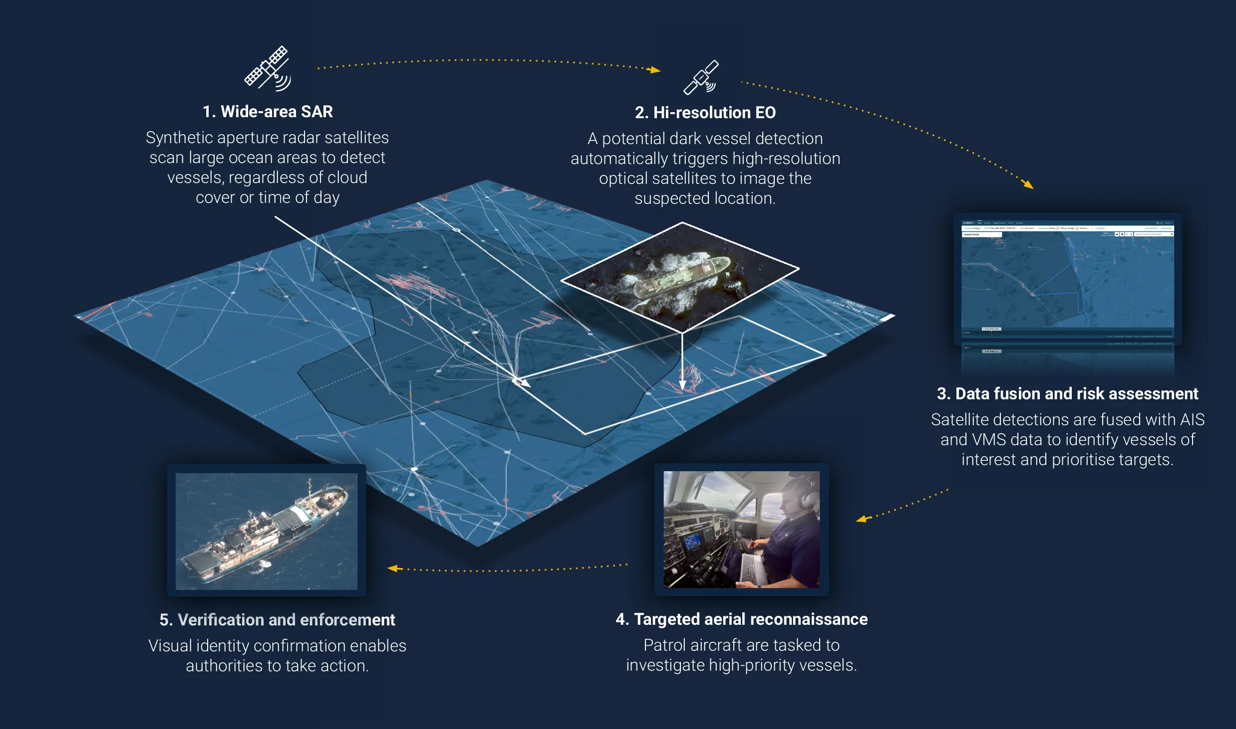
Maritime threats rarely appear in one feed, one image, or one system. Starboard helpsdefence and intelligence teams detect, assess, and act faster by bringing fragmented maritime data into a single workflow for intelligence production and operational tasking.
Multi-sensor fusion across maritime data sources,
Behavioural analysis to identify high-risk activity,
Intelligence-led prioritisation and tasking,
A practical workflow from sensor input to intelligence output.
Maritime intelligence teams are under pressure to make sense of growing sensor volumes, fragmented data sources, and increasingly complex operational demands. Analysts needmore than visibility. They need a workflow that helps them fuse inputs, prioritise risk, andmove from detection to usable intelligence output quickly and confidently.
Bring together AIS, VMS, SAR, optical imagery, RF detections, and behavioural indicators inone environment so analysts can assess activity faster and with more context.
See how Starboard supports a more connected approach to maritime GEOINT production,reducing the friction caused by disconnected tools and fragmented workflows.
Move from detection to intelligence output faster.
Support triage, prioritisation, tasking, and intelligence production in a workflow built foroperational teams.
Come and get a demo to see how Starboard can help your organisation identify high-risk activity earlier, focus limited collection and patrolassets more effectively, and turn sensor data into operationally useful intelligence.
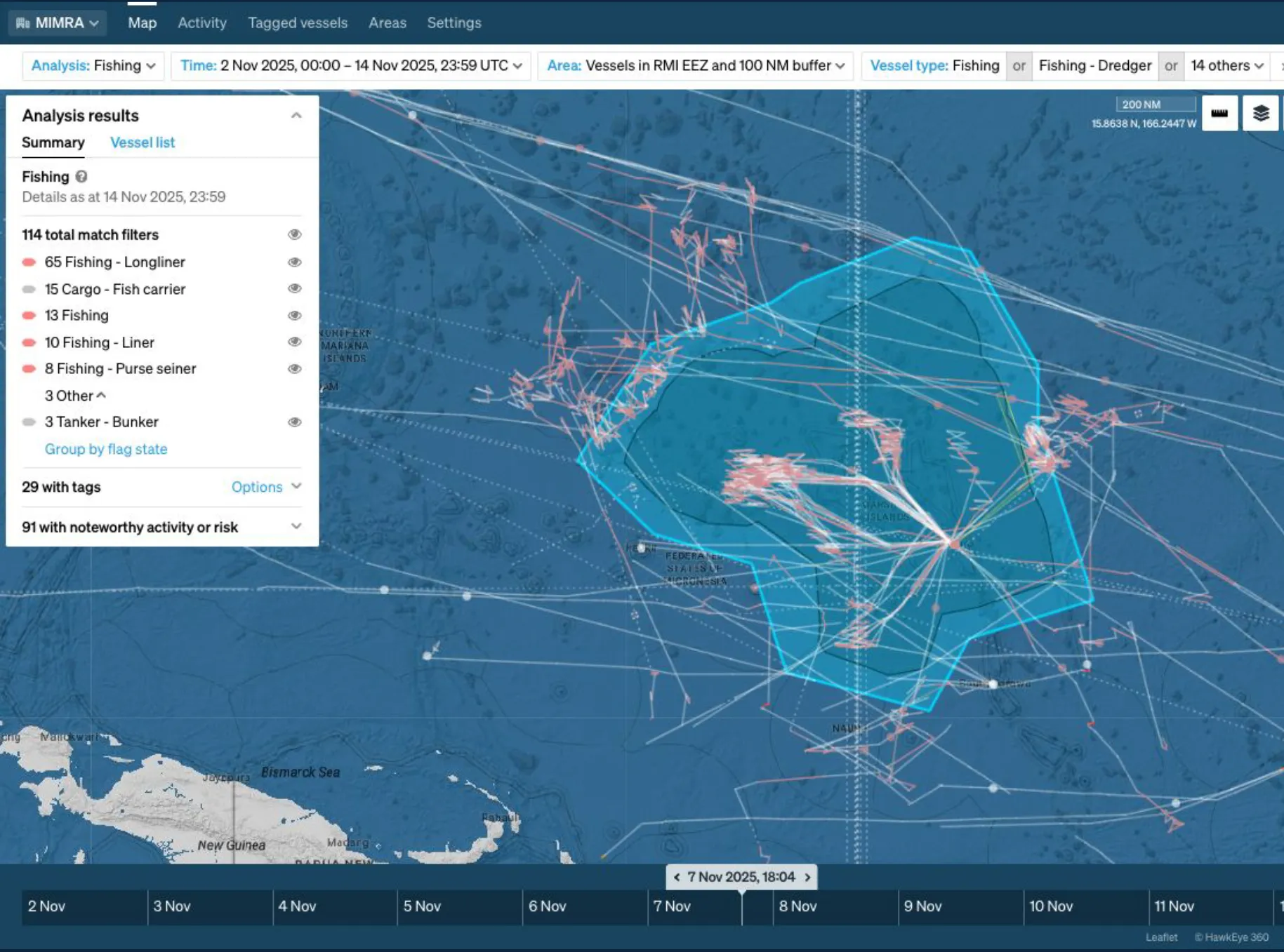
Operation Nightwatch is the featured proof point we’ll be showing at GEOINT 2026.
The operation combined wide-area satellite detection, AIS and VMS data, intelligenceanalysis, and airborne verification to support dark-vessel surveillance in the Marshall IslandsEEZ. The result was a practical, intelligence-led workflow that reduced the time betweendetection and on-scene inspection from days to hours.
For GEOINT audiences, it demonstrates a clear methodology: detect with wide-areasensing, confirm with high-resolution imagery, and verify with operational assets.
Multi-sensor fusion across maritime data sources,
Behavioural analysis to identify high-risk activity,
Intelligence-led prioritisation and tasking,
A practical workflow from sensor input to intelligence output.
We’ll be sharing a practical view of how maritime intelligence teams can work moreeffectively across disconnected tools, fragmented sensor inputs, and growing operational complexity.
If you’re attending GEOINT 2026 and want to see how Starboard supports maritime GEOINTproduction, you can book in person with the team.We’ll walk you through Operation Nightwatch, our multi-sensor fusion approach, and howStarboard can help turn your maritime data into operational intelligence.
Form to be added here.