The Starboard team will be at booth 1233.
Share a mission requirement, workflow constraint, or area of interest, and we’ll work through it with you in a live maritime GEOINT workflow.
GEOINT and maritime teams deal with massive data set across multiple tools, and the detection‑to‑tasking cycle is often too slow for fast‑moving or grey‑zone activity.
Starboard is a maritime intelligence platform built for analysts for and operators working across defence, intelligence, and critical infrastructure missions.It fuses multi-source data with AI-driven behavioural analytics to predict vessel intent, delivering an integrated operational picture that supports triage, tasking, and intelligence production.
For GEOINT teams, that means less manual fusion across disconnected tools and a faster path from collection to evidence-ready output.
Starboard integrates via APIs and data products into existing GEOINT exploitation systems and data platforms, so maritime analytics and observations flow directly into your production and targeting workflows.
Critical maritime infrastructure protection
Monitor vessel activity near subsea cables, offshore energy, and ports. Identify behaviour that warrants attention and produce outputs suitable for escalation or disclosure.
Dark vessel detection and characterisation
Detect vessels operating without AIS, assess likely intent using behavioural indicators, and link activity to ownership or operator networks.
Large-ocean enforcement and sovereignty operations
Support detection and tasking across exclusive economic zones measured in millions of square kilometres, while maintaining decision authority with the host nation.
Coalition and unclassified intelligence workflows
Produce and share maritime intelligence at the unclassified level, with defined pathways to higher classification where required.
Mat Brown and KevinDe Bartolomeo will be at the booth throughout the symposium.
Book a time in the link below or send us an email.
We can run demonstrations securely on site using live data where possible. For sensitive use cases,discussions can move off the booth floor.
A vessel of concern you are trying to characterise
An area of interest with suspected grey-zone activity near critical infrastructure
A data source that needs to be integrated with an existing collection A capability gap in your current maritime intelligence workflow
An RFP, programme, or teaming opportunity you’re exploring
If you have a specific problem or requirement, bring it along to review, for example:
Book a meetingEmail us at demo@starboardintelligence.com
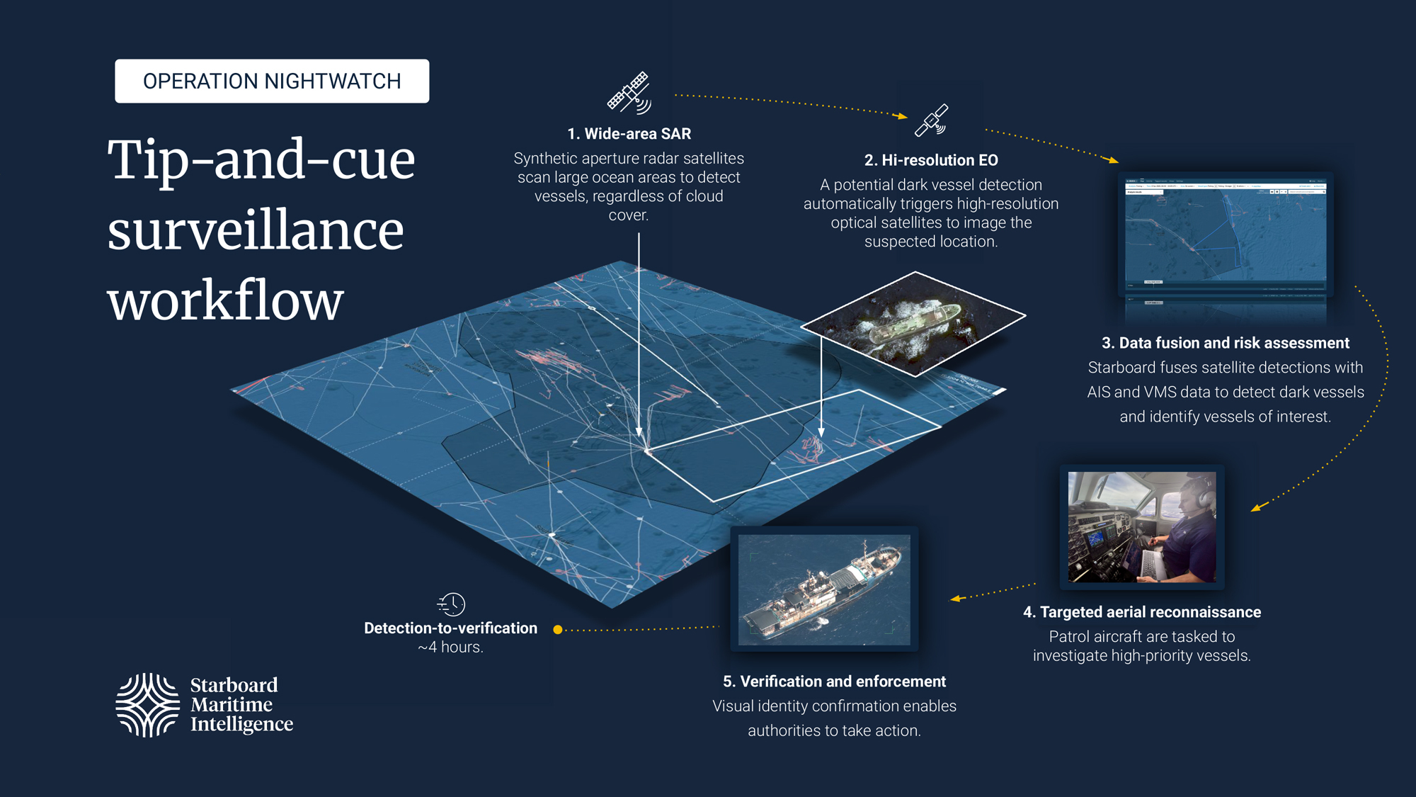
Operation Nightwatch shows Starboard applied in a real operational setting. The results are public, and the workflow transfers across missions. USGIF will feature the operation in a short vignette during the GEOINT Symposium 2026 Main Stage opening.
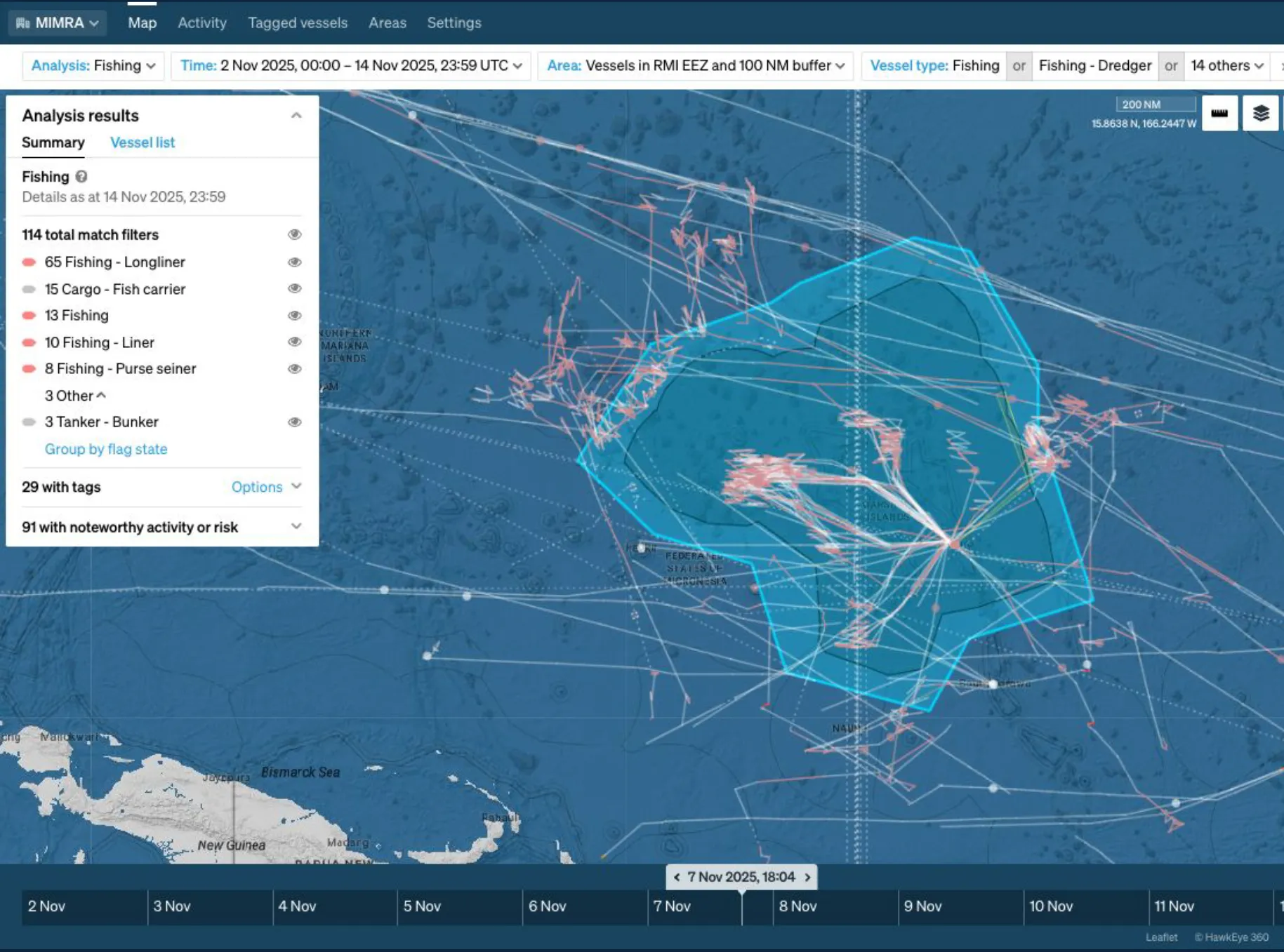
In late 2025, the Marshall Islands Marine Resources Authority ran a 12-day maritime enforcement campaign across a 2-million-square-kilometre exclusive economic zone, an area where ocean exceeds land by roughly 11,000 to one.
Starboard orchestrated the intelligence workflow, and our Senior Oceanographer Moritz Lehmann was embedded in Majuro throughout the campaign.
Starboard fused wide-area satellite detections, high-resolution imagery, vessel tracking, and confidential monitoring data into a single operating picture
Behavioural indicators were used to continuously prioritise vessels of concern, including time at sea without port calls, high-seas transshipment, interactions with listed vessels, and conflicting identity signals
Prioritised targets were passed directly to airborne patrol assets, including in-flight re-tasking when new detections emerged
Every operational decision remained with Marshall Islands authorities
Detection-to-airborne verification averaged approximately four hours, down from days under previous workflows
43 vessels were detected through automated workflows
6 high-priority vessels were verified through targeted reconnaissance
Links:
Read the full case study →
Field notes from Majuro, by Moritz Lehmann → /articles/operation-nightwatch-field-notes
Mat Brown will present Starboard’s Lightning Talk at GEOINT Symposium 2026, drawing on Operation Nightwatch and recent work on subsea cable protection.
The session outlines how a repeatable multi-sensor workflow applies across different mission types, including large-ocean enforcement and infrastructure protection.Session time and location will be confirmed when the GEOINT agenda is published.

Book a slot to walk through a live maritime GEOINT workflow tailored to your mission, data sources, or programme priorities.
Use the form to schedule a time with Mat Brown or Kevin DeBartolomeo at Booth 1233. If you prefer to reach out directly, contact Mat at mat.brown@starboardintelligence.com or Kevin at kevin.debartolomeo@starboardintelligence.com.