Operation Nightwatch case study—dark-vessel enforcement in the Marshall Islands

Working with the Marshall Islands Marine Resources Authority (MIMRA) and regional partners, authorities conducted a targeted maritime surveillance campaign across the Republic of the Marshall Islands’ Exclusive Economic Zone (EEZ). By combining satellite intelligence, maritime data, and airborne verification within a unified operational workflow, the operation compressed the time from initial detection to on-site verification from days to hours.
For large-ocean states operating with limited patrol assets, this model demonstrates how intelligence-led maritime surveillance can be operationalised to prioritise vessels of concern for inspection or intervention.
Pacific Island nations have the largest ocean areas relative to land surface in the world. Monitoring these waters is essential for protecting their fisheries, enforcing maritime law, and safeguarding national sovereignty.
The scale of these ocean territories creates a persistent operational challenge. Patrol vessels and surveillance aircraft must cover vast areas, while illegal operators often exploit gaps in visibility by operating without identification or manipulating vessel tracking systems.
Traditional patrols are conducted as systematic surveys and struggle to locate these vessels efficiently. Without intelligence-led prioritisation, enforcement assets spend significant time searching large areas with limited information.
Operations such as Nightwatch demonstrate how authorities can shift from broad patrol patterns toward risk- and intelligence-based surveillance, directing limited patrol assets toward the highest-priority targets.
Operation Nightwatch was led by the Marshall Islands Marine Resources Authority (MIMRA) as the national fisheries enforcement agency in collaboration with Starboard Maritime Intelligence. Operational priorities, surveillance decisions, and airborne tasking were directed by MIMRA in coordination with regional partners.
Starboard provided technical leadership and the orchestration layer that fused multiple data sources into a comprehensive maritime intelligence picture. This enabled analysts to identify vessels exhibiting suspicious behaviour and prioritise targets for verification quickly.
The Forum Fisheries Agency (FFA) supported the operation by providing the regional surveillance aircraft and coordinating the targeted flight plans. In addition, the regional body supplied radio frequency satellite detections and ongoing intelligence analysis to help guide the mission.
Satellite sensing and automated tasking capabilities were provided by Vantor through its Maritime Sentry system.
All operational decisions remained under national authority.
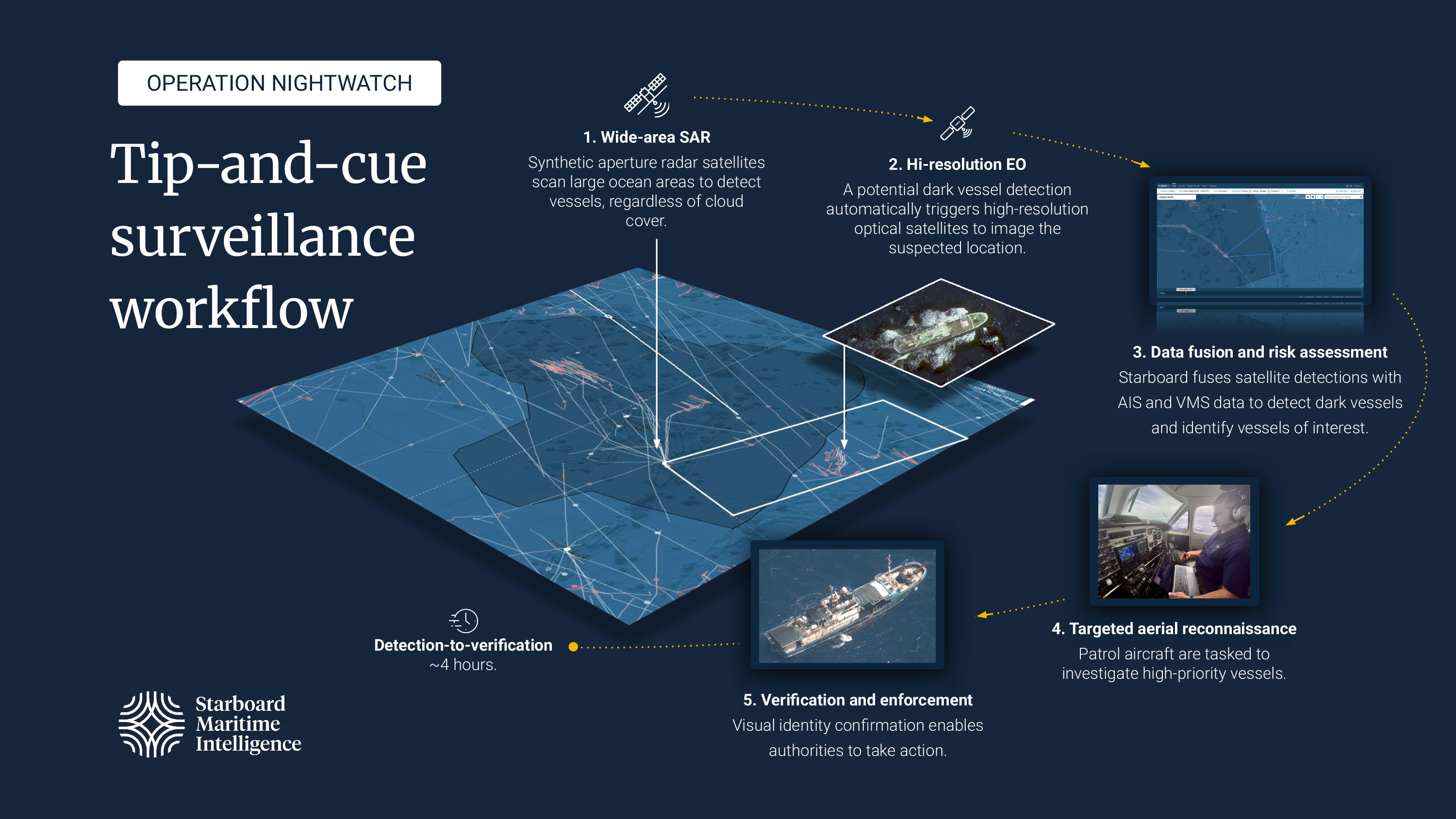
Operation Nightwatch used a tip-and-cue workflow designed to reduce the time required to identify and verify suspicious vessels.
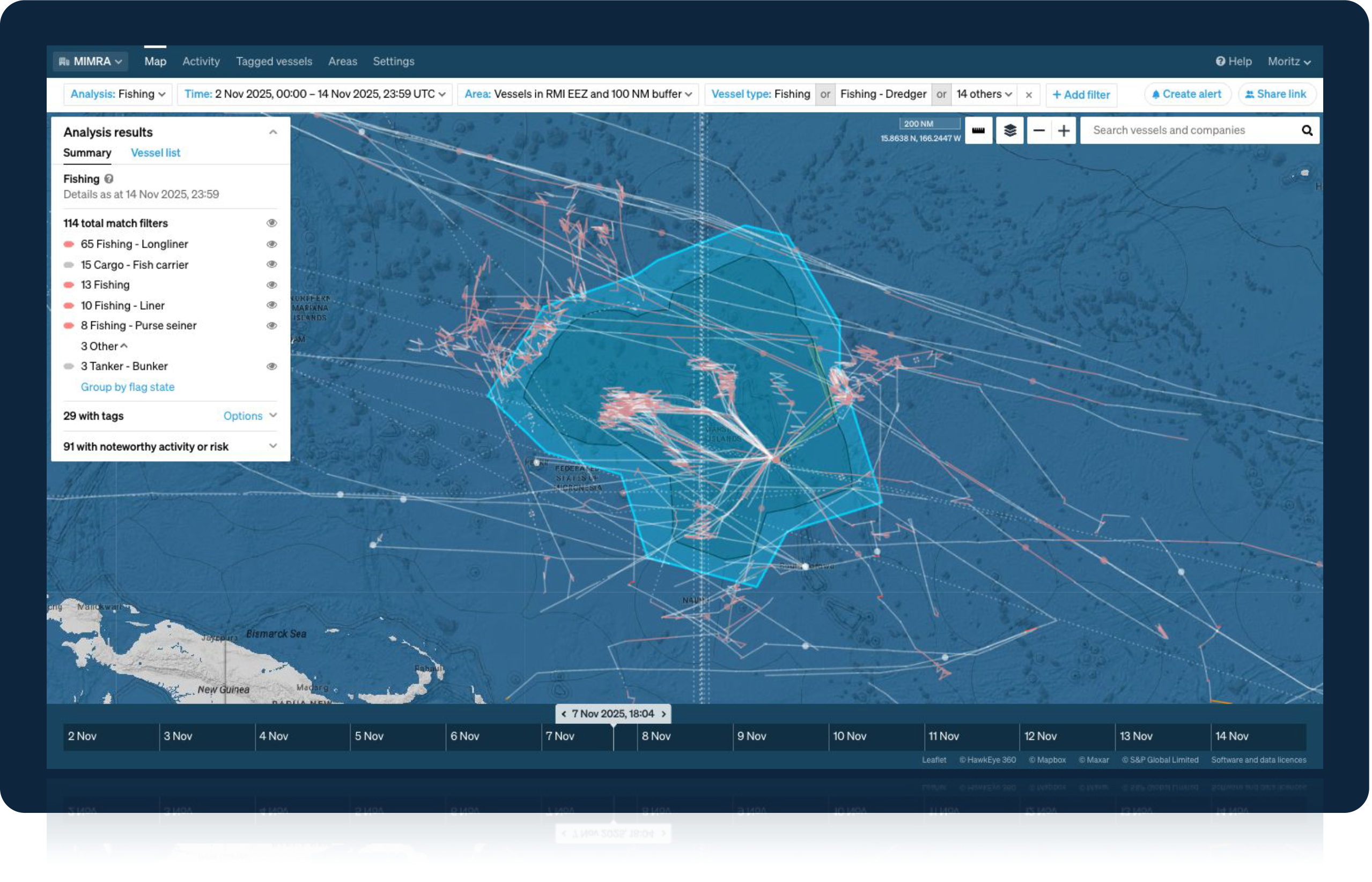
Satellite sensors and vessel-tracking data were used to identify vessels operating in the region and detect anomalies in behaviour.
Starboard’s platform fused satellite data, AIS signals, and other maritime information into a unified operational picture, allowing analysts to assess vessel activity and identify potential vessels of interest.
Within this common operating picture, analysts reviewed patterns of behaviour and prioritised vessels for further investigation based on operational risk factors.
Airborne patrol assets were directed to verify high-priority targets, confirming vessel activity on the water.
This workflow enabled authorities to prioritise patrol resources based on intelligence, focusing surveillance assets on vessels most likely to require enforcement attention.
Outcomes
Operation Nightwatch demonstrated how intelligence orchestration and multi-source data fusion can significantly improve the efficiency of maritime enforcement operations.
Authorities were able to move from wide-area detection to airborne verification in an average of approximately four hours, reducing the time required to confirm suspicious activity across the EEZ.
Across the operation, analysts identified 43 vessels, with six prioritised as high-risk targets for aerial verification.
These results were achieved not by adding a single new sensor, but by orchestrating existing and commercial data sources into an intelligence workflow that supported timely surveillance decisions.
By prioritising patrol effort using intelligence, authorities were able to focus surveillance assets on specific vessels of interest rather than conducting broad search patterns across the entire EEZ.
For coastal and island nations, the primary challenge in maritime enforcement is not simply collecting more data. It is coordinating multiple sources of information and translating them into operational decisions quickly enough to act.
Operation Nightwatch demonstrates how large-ocean states can operationalise intelligence-led maritime surveillance by combining wide-to-fine area sensing, multi-source data fusion, and intelligence-led tasking of patrol assets.
When applied consistently, this model allows authorities to prioritise limited patrol capacity, strengthen maritime governance, and improve the efficiency of surveillance operations across vast maritime zones.
National fisheries authority responsible for maritime monitoring and enforcement operations.
Provided the maritime intelligence platform used to fuse data sources into a unified operational picture and support analyst-led prioritisation of surveillance targets.
The regional fisheries body provided intelligence analysis, air support and radio frequency satellite detections.
Provided satellite sensing and automated tasking capabilities through the Maritime Sentry system.
Operation Nightwatch illustrates how intelligence workflows can support more effective maritime enforcement across large ocean territories.
By combining wide-to-fine area satellite sensing with analyst-driven prioritisation and rapid verification, authorities can operationalise intelligence-led surveillance and direct patrol resources toward the vessels that matter most.
For large-ocean states facing similar enforcement challenges, the Nightwatch model provides a practical example of how modern maritime intelligence can support maritime security, fisheries protection, and sovereign enforcement capability.
For a first-person view from the surveillance aircraft during Operation Nightwatch, read “Operation Nightwatch–field notes from the Marshall Islands EEZ” by Dr. Moritz Lehmann.
Learn more about how Starboard is the common operating picture for the maritime world.